Kayaking in Saxis, Virginia & Exploring the Water Trails
- Laura Scharle

- Dec 30, 2023
- 5 min read
Updated: Jul 22, 2025
This article was originally written by Laura Scharle (Creator of Delmarva Trails & Waterways) for the Chesapeake Conservancy's website, FindYourChesapeake.com. That site is no longer live and its content is supposed to be migrated to the National Park Service Chesapeake Bay Office website, but until that happens, you can read the full article here.


Whenever I mention I'm going to be kayaking in Saxis, Virginia to a friend or neighbor, I almost always get a confused look like, “where’s that?” As a resident of Berlin, MD, it’s only a little over an hour away, but unless you’re from the area, you probably haven’t heard of it.
Saxis is a small waterman’s town located on the eastern shore of Virginia, just a stone’s throw from the Maryland border. Just several miles to the northwest is Crisfield, Maryland, but it takes about an hour to drive between the two towns because they are separated by the Pocomoke Sound. Saxis is also technically an island, being separated from the mainland by a wide salt marsh, but you won’t need a boat to visit, as there is a causeway that supports Saxis Road, providing access for vehicles to reach the island. The salt marsh is all protected land, as most of it is a designated Wildlife Management Area under Virginia’s Department of Wildlife Resources.
The first time I drove out to Saxis was years ago when my husband and I were bored on a Sunday afternoon in January and we literally went out for a Sunday drive. We were driving out on Saxis Road (state route 695) and I knew we were getting close to the bay since the forest was thinning and we were surrounded by a ghost forest. Ghost forests are the remnants of a forested area that are mostly dead, barren trees, all a result of climate change, sea level rise, and saltwater intrusion. I never like to see ghost forests because it’s a stark reminder of what a warming climate is doing to our natural world, but there’s also something mysterious and intriguing about them. It’s like a little glimpse into what the land may have looked like over a century ago. Once we were out of the ghost forest and surrounded by marsh, I could see the tiny town on the horizon.
Fast forward over ten years, and this same experience happened not long ago when I ventured out to Saxis to explore the area by kayak. I exited the mainland, drove through the ghost forest, and I saw the town on the horizon. The only difference is that the road had deteriorated a bit over the years, likely due to rising sea levels and bay water more frequently covering the road. Luckily, a crew was out that day, working to patch up the asphalt and reinforce the road.
There are several water trails that meander in and around the Saxis area, and I was ready to paddle some new spots. There are three areas to launch that are all in very close proximity to the town: a boat ramp at the end of Hammock Road (a slight detour as you approach town), a soft launch off of Matthews Road, and the main public boat ramp at Saxis harbor. I had paddled from Hammock Road in the past, so I chose to launch at the harbor this time. This launch almost felt luxurious, with interpretive signage, a picnic pavilion, water fountain, and clean, flushing toilets!


Aside from the restrooms, a fishing pier, and a delicious restaurant, the rest of the waterfront in Saxis is a working waterfront, loaded with shedding shacks, piles of crab pots, oyster cages, and numerous workboats owned by the watermen that live nearby. When you’re in Saxis, you are really immersed in the local, Chesapeake culture of working the water.
Although I had paddled the Saxis area at least three times prior (more about that later), there were still plenty of waterways that I had not yet seen. This time, my goal was to circumnavigate Tunnels Island, a 6.5-mile loop that should only be attempted by experienced paddlers. The cool thing about paddling Tunnels Island though, is that there is a shorter 2-mile loop that is suitable for less experienced paddlers. I entered Fishing Creek and headed west, with the intention of paddling around the island in a counter clockwise direction, but when I hit the Pocomoke Sound, I noticed the wind out of the northwest had picked up to a point that it wouldn’t be enjoyable to paddle that direction. I quickly switched my plan and headed east through Fishing Creek towards Beasley Bay and along the south shorelines of Tunnels Island. This allowed me to stay in a sheltered spot from the wind, but still get the full Saxis experience I was looking for.
Along my paddle, I was pleasantly surprised by the variety of bird life around me. I saw great egrets strutting in the shallow waters, clapper rails laughing from their hiding spots in the marsh, osprey diving for fish, bald eagles soaring above, black skimmers skimming the water’s surface, and several species of sandpipers and sanderlings flitting around the sandy beaches.

It’s important to note that Tunnels Island is privately owned, so if the extensive sandy beaches are luring you in, it’s important to stay below the high tide line. I did stop for a quick break to stretch my legs and eat a quick snack. While I was on the beach, I saw a good number of spawning horseshoe crabs, as well as laughing gulls, chowing down on some of the eggs. Since it was early June, it was also prime nesting season for diamondback terrapins, so I even spotted some fresh turtle tracks in the sand.
Even though I was in a pretty protected area, the wind began to pick up even more, so I decided to start heading back before it got too gusty. On the way back, several work boats passed me, coming in and out of Saxis harbor. With each boat that passed, I got more and more curious about the locals and what it would have been like to grow up in Saxis in years past. There is a small museum about the history and culture of Saxis, but it was not open the day I visited, so I am now eager to return at a later date to check it out.
Speaking of additional visits to Saxis, I should mention that I have paddled other portions of Saxis in the past. One time I was venturing the long distance from Crisfield to Saxis and completed a 6-mile open water crossing across the Pocomoke Sound. It was a rare day of completely calm winds and my husband was willing to pick me up at the end so I didn’t have to paddle back to Crisfield, but I wouldn’t recommend paddling across the sound in any conditions unless you’re a super experienced paddler! The thing that was noteworthy and slightly amusing about that trip was that there is actually a state line border sign in the middle of the sound. It’s a little sun faded, but it clearly shows when you cross the border between Maryland and Virginia!

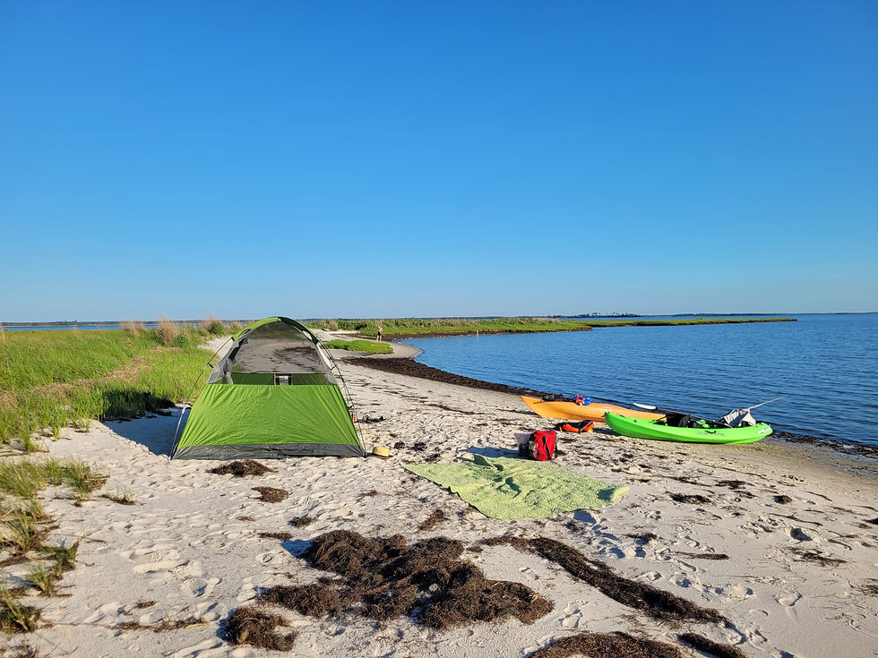
Another time my husband, my son, and I went kayak-camping in Saxis. The Saxis Wildlife Management Area (WMA) allows primitive camping as long as you get an access permit in advance. There are a few small beaches within the WMA that are suitable for camping, but be sure to study the map to ensure you don’t set up camp on private land.

If kayak-camping is a bit more than you’re willing to take on, consider a day trip out of the launches within the WMA, Marsh Market and Cattail Creek. Both launches feel like they’re a world away from civilization and the vast, open salt marshes provide a quiet escape, even if you only have a few hours to spare.
No matter what section of Saxis you decide to paddle, check out the handy, interactive maps on Virginia Water Trails before you go!